Sustained rains, wind could last through Tuesday
**UPDATED 208 PM** The National Hurricane Center officially upgraded Harvey to a Category 3 storm just after 2 p.m.
By LPR Staff
Editor/POST-REGISTER
The National Oceanic and Atmospheric Administration (NOAA) delivered an updated on Friday afternoon regarding the impending landfall of Category 2 Hurricane Harvey, currently barrelin
g his way across the Gulf of Mexico.
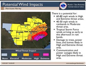
According to NOAA meteorologist Paul Yura, tropical storm bands are expected to begin arriving in South Central Texas as early as Friday afternoon, with rain bands beginning to arrive Friday evening.
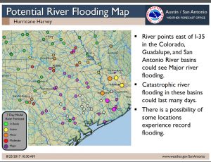
The rains, he said, could continue through the weekend and into the middle of next week, depending on “where Harvey decides to stall.”
The outlook for Caldwell County continues to show a moderate threat for tropical storm force winds in southeastern Caldwell County, including Lockhart, with an “elevated” threat in the northwestern portion of the county. Damage to homes, trees and power lines is likely in many areas.
Yura said the storm is holding steady at Category 2, with sustained winds of 110 mph. However, as the massive storm, stretching more than 400 nautical miles wide, hovers over the Gulf of Mexico, there is still a chance the storm could intensify before making landfall near Corpus Christi this evening.
Current forecast models, which Yura said he sees no reason to change at this time, call for the likelihood of rainfall totals estimated at 6 – 8 inches for much of South Central Texas, though some areas, including portions of Caldwell County, could see totals in excess of 12 – 15 inches. Much of the forecast is dependent upon whether the storm intensifies prior to making landfall, and how the rain bands dissipate after landfall.
NOAA will periodically update the status of the storm as landfall nears, with the next update expected no earlier than 5 p.m. on Friday.
The Post-Register will continue to monitor the situation and provide updates as more information becomes available.


