El Niño takes over in 2026: What it could mean for Caldwell County
By Anthony Collins
LPR Editor
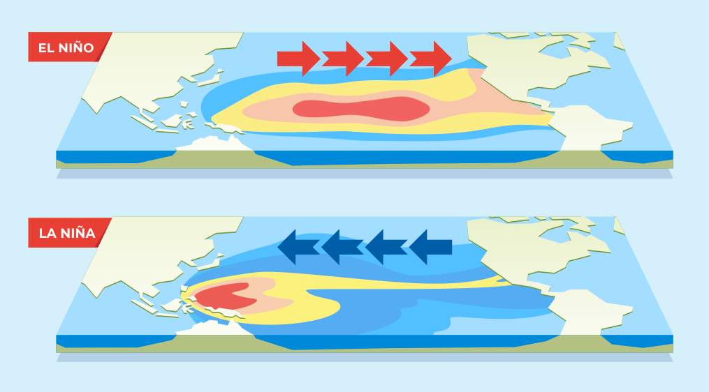
Weather in Texas can change faster than a pickup truck radio station, but some larger patterns can give forecasters an idea of what the coming months may bring. Two of the most important patterns are El Niño and La Niña. While they begin thousands of miles away in the Pacific Ocean, both can influence temperatures, rainfall, drought and severe weather across Texas, including here in Caldwell County.
For much of early 2026, the Pacific was coming out of a La Niña pattern. That changed in June, when the National Oceanic and Atmospheric Administration officially announced that El Niño had developed. As of July 9, NOAA reported that El Niño was continuing to strengthen. Forecasters said there was a 97% chance the pattern would remain through early spring 2027. NOAA also placed the chance of a very strong El Niño during October through December at 81%. That means Caldwell County is expected to spend the remainder of 2026 under an El Niño pattern.
El Niño and La Niña are opposite phases of a larger natural climate cycle called the El Niño-Southern Oscillation, or ENSO. The cycle involves changing ocean temperatures, winds and air pressure across the tropical Pacific Ocean near the equator. These changes can shift the jet stream and influence weather patterns across much of the world.
El Niño is the warm phase. It develops when surface waters in parts of the central and eastern tropical Pacific become warmer than normal. La Niña is the cool phase. It occurs when those same waters become cooler than normal.
There is also an ENSO-neutral phase, when ocean temperatures are close to average and neither El Niño nor La Niña is controlling the larger pattern. These phases do not follow a regular yearly schedule. They can last for several months or more than a year, and conditions often shift from one phase to another every two to seven years.
The easiest way to remember the difference is that El Niño generally gives Texas a better chance of cooler, wetter weather during the fall and winter, while La Niña often favors warmer and drier conditions. During El Niño, the Pacific jet stream usually shifts farther south. That can guide more storm systems across the southern United States, bringing additional clouds, rain and occasional winter weather.
La Niña generally pushes the main storm track farther north. Texas may then receive fewer winter storms, increasing the chances of warmer temperatures, drought and wildfire concerns. However, neither pattern guarantees a certain type of weather. El Niño does not mean it will rain every week, and La Niña does not mean every day will be dry. Other factors, including Gulf moisture, cold fronts, tropical systems and high-pressure ridges, can still take control of Texas weather for days or weeks at a time.
The effects of El Niño are usually weaker during the summer and become more noticeable during the fall and winter. That means Caldwell County should not expect immediate relief from the summer heat simply because El Niño has arrived. National Weather Service forecasters have noted that Central Texas can still experience drier-than-normal conditions during the second half of an El Niño summer, along with slightly above-normal temperatures. The rainfall signal becomes more favorable by fall, when there is a somewhat greater chance of above-normal precipitation.
For local farmers, ranchers and gardeners, that means the remainder of summer could continue to bring periods of heat and dry soil. Any scattered thunderstorms may provide temporary relief, but rainfall totals can vary greatly from one part of Caldwell County to another. As fall approaches, the strengthening El Niño could begin sending more storm systems across Texas. That may improve rainfall chances and help replenish soil moisture, stock tanks and area waterways. The greatest local effects may become noticeable during the winter of 2026-27.
A typical El Niño winter brings a greater chance of cooler and wetter conditions across the southern United States. NOAA says El Niño’s southward-shifted storm track often creates stormier weather across the region, with increased chances of rain and occasional snow or ice. For Caldwell County, that could mean more frequent cloudy periods, cold rains and stronger winter storm systems than residents experienced during the previous La Niña pattern. It does not necessarily mean a major freeze or ice storm is coming. Long-range climate outlooks describe general trends over an entire season, not individual weather events.
Additional fall and winter rainfall could help improve drought conditions, but recovery would depend on where the rain falls and how steadily it arrives. Several moderate rain events spread across several weeks are generally more helpful than one heavy downpour. Slow, steady rainfall has a better chance of soaking into the ground, while intense storms can produce runoff and flash flooding before much of the water reaches deeper soil. Even during a wet El Niño winter, Caldwell County residents should remain prepared for stretches of dry weather. Water conservation and wildfire awareness may still be important, especially until dependable rainfall returns.
El Niño gives forecasters an important clue about the direction the weather may take, but it is not a guarantee. Every El Niño develops differently. Some bring widespread rain to Texas, while others produce uneven rainfall that leaves certain communities’ wetter and others still waiting.
For Caldwell County, the most reasonable outlook for the rest of 2026 is continued summer heat with possible dry stretches, followed by improving rainfall chances during the fall and a potentially cooler, wetter winter. In other words, El Niño may eventually bring Caldwell County some welcome moisture, but Texans probably should not put away the sunscreen or the water hose just yet.