Lockhart shaping future growth along major gateways
By Anthony Collins
LPR Editor
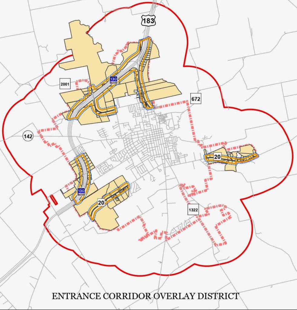
As Lockhart continues to grow, city officials are looking beyond what new development brings to town and placing more attention on what that development will look like when residents and visitors first enter the city. The City of Lockhart is moving forward with its Entrance Corridor Overlay District, or ECOD, a zoning tool designed to establish additional development standards along some of the community’s most visible entrance corridors.
The proposed overlay includes properties along portions of U.S. 183, State Highway 130 and FM 20. The Lockhart Planning and Zoning Commission held a public hearing Wednesday, Aug. 26, regarding the zoning map changes needed to place those properties within the new overlay district. The proposal is scheduled to go before the Lockhart City Council for another public hearing Sept. 15. Although the ECOD may be new to the city’s zoning map, the development standards themselves have been in the works for several months. The Planning and Zoning Commission considered the regulations in February, and the City Council adopted the ECOD language on March 17.
That action created the rules, but it did not place any individual properties inside the district. The current zoning map amendment is the step that would establish where those regulations apply. The idea behind the overlay is straightforward: Properties keep their underlying zoning, but commercial, industrial and multifamily developments located inside the ECOD would also have to meet an additional set of standards.
According to the city’s ordinance, the goal is to create high-quality and consistent development along major entrances into Lockhart while creating a more welcoming appearance for people arriving in the community. For existing property owners, the regulations do not automatically require current buildings or businesses to be rebuilt or remodeled. Existing developed properties are generally exempt unless redevelopment, major site modifications, building additions or certain zoning changes involving commercial, industrial or multifamily uses are proposed.
For new development, however, the overlay could have a noticeable impact. Among the standards is a 50-foot front setback for properties facing an entrance corridor and a minimum 10-foot interior side setback. Multifamily buildings within the district are limited to three stories or 35 feet, while nonresidential buildings within 100 feet of the corridor are also limited to 35 feet.
Parking is another major component. The ordinance is designed to reduce the appearance of large parking lots from the roadway by directing most parking to the sides or rear of primary buildings. Covered or structured parking must generally be located behind the primary building or entrance, so it is not prominently visible from the designated corridor. Landscaping requirements are also stronger inside the overlay. Developments would be required to provide at least a 15-foot landscaped buffer along corridor street frontage between the sidewalk and developed portions of the property. The buffer is expected to include native trees, grasses, shrubs and other plantings, with trees generally spaced no more than 40 feet apart. Parking, loading areas and accessory structures would not be permitted within that landscaping buffer, although approved signs could be located there. The regulations also include protections for certain existing mature trees.
The ECOD also limits some types of businesses and land uses along the city’s primary gateways. Uses prohibited within the overlay include RV parks, truck stops or travel plazas, outdoor vehicle storage, manufactured home sales, self-storage facilities, warehouses, auto repair and tire shops, welding or machine shops, certain manufacturing and fabrication operations, feed stores and several other uses.
Other businesses, including automobile sales, gas stations, convenience stores and auto parts stores, would not necessarily be prohibited but would require a Specific Use Permit before they could be developed within the corridor. The overall standards extend beyond land use and landscaping and include requirements involving building appearance, setbacks, parking, sidewalks, signs and exterior lighting. The intent is to improve the appearance of future development along Lockhart’s primary gateways rather than allow each major entrance to develop without a consistent design standard.
Because the map amendment affects individual properties, notices have been provided as part of the public zoning process, including notification to affected property owners and owners of property within the required notification area. Residents should also remember that City Council business does not take place without a public agenda. City legal notices are published through the Lockhart Post-Register, and upcoming agendas and meeting information are also available through the City of Lockhart’s website.
That means residents who want to know what their elected officials will be discussing have multiple opportunities to stay informed before a meeting takes place. Checking the public notices and agendas in the Post-Register or periodically visiting the city’s website is one of the simplest ways to follow issues that may affect property, development and the future of the community.
That public availability is also important when questions arise over whether an issue was somehow being kept from residents. Disagreement with a proposal is certainly part of the public process, and residents have every right to voice those concerns. However, a lack of personal awareness of an agenda item should not, by itself, be used as evidence that the City Council was attempting to hide the issue. Public notices, posted agendas, and public hearings exist specifically to give residents an opportunity to learn about proposals and participate before final decisions are made.
Recognizing that many property owners and other attendees were not yet familiar with the specific provisions and requirements of the ECOD, the Planning and Zoning Commission voted to postpone the public hearing until November 18, 2026, when the hearing will continue.
To provide additional opportunities for the community to learn about the proposal and better understand how the ECOD would work, the Planning and Zoning Commission will also hold a non-voting workshop on October 28, 2026. No formal action on the proposed overlay will be taken during the workshop.
For Lockhart, the decision represents more than another change to the zoning map. As development continues to push outward along U.S. 183, SH 130 and FM 20, the ECOD could help determine what some of the first views of the city look like for decades to come. And for residents who want a voice in what that future looks like, the opportunity begins with staying informed, reading the notices, reviewing the agenda and showing up when those decisions are being discussed.